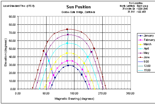
| Download sunpath.zip | This Excel spreadsheet creates a graph of the sun's position for a given time of day and month of the year for a point on the earth's surface. This type of sunchart or sun path plot is commonly used for designing solar energy installations, but I use it for location and aerial photography. Any cinematographic supply house can sell you a slide-rule calculator or proprietary software to do the same thing for $50-150, but this one's free.
This program was tested on Excel 2000 for the PC. When you open the spreadsheet, you will have to enable the macros in the spreadsheet when prompted by Excel. Keep in mind that the graph is in standard local clock time. You will have to add/subtract an hour for those months when daylight savings time is observed. To use this program, you need to know the latitude and longitude of the location you're interested in. Although I've shown a fairly precise location, you don't really need more than a degree or two of accuracy. So you should be able to find the lat/long by looking on a globe, atlas, or map. On the web, you can look up a place name in the USGS database or browse the maps on Terraserver (Select "topo map" and click on the "info" button to see the lat/long grid legend). If you want to see the heading of the sun's position as it would appear if sighted by a compass, you will need to know the magnetic variation (the deviation of true geographic north from the compass' magnetic north). You can get this from an aviation chart, a nautical chart, or by looking up in a NOAA database (you want the "D" or Magnetic Declination value there). You can also get within a few degrees by looking at a world or continent map from USGS. |
| This Program is Copyright © 2003 Robert L. Bleidt ALL RIGHTS RESERVED. This Program is offered without warranty or indemnification of any kind, contains bugs and errors, and its use is AT YOUR OWN RISK. It may be freely distributed (including reasonable duplication/media fees) in its unmodified form. |
| Send mail on technical problems with this page to: [email protected] |
